
A record breaking Super El Niño is developing on top of a climate system that has already warmed significantly since the mid twentieth century, and the combination is producing a summer of disasters that outpaces anything seen in the previous two major El Niño cycles. Forecasters now put the odds of a record El Niño forming by the end of 2026 at 81 percent, and the early damage, in human lives, crops and economic output, suggests this is not going to behave like a typical event.
The Human Toll of the 2026 Heatwaves
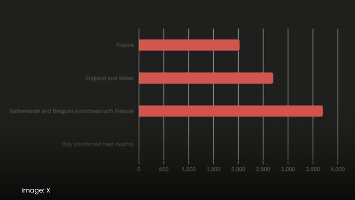
The clearest and most immediate impact is measured in lives lost. A blistering June heatwave, the hottest on record for Western Europe, has caused more than 3,700 excess deaths across France, the Netherlands and Belgium, with France alone estimated to have lost around 2,025 people in a single week. In England and Wales, a joint study by Imperial College London and the Met Office found more than 2,700 deaths linked to two extreme heatwaves in May and June, with researchers directly attributing 42 percent of those deaths to human caused climate change. Italy is enduring its third heatwave of the summer, driven by a powerful African anticyclone, which has caused at least seven confirmed heat deaths and triggered wildfires forcing evacuations in Sicily and Naples. Much of this toll goes underreported, since extreme heat typically kills by worsening existing heart, respiratory and kidney conditions rather than through heatstroke alone, and hotter nights prevent the body from recovering, raising mortality further for vulnerable populations.
Why the 2026 Super El Niño Is Different From 1998 and 2016
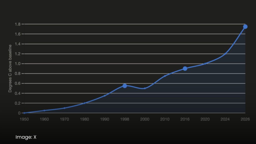
What separates this event from past strong El Niños, including the historic 1997 to 1998 cycle, is the baseline it’s building on. Global temperatures have already climbed roughly 1.2 degrees Celsius above mid twentieth century levels due to background warming from fossil fuel emissions, meaning this El Niño isn’t just adding heat, it’s amplifying an already elevated starting point. That combination is why daytime heatwaves this year are running 3 to 4 degrees Celsius hotter than typical seasonal averages, a gap that didn’t exist in 1998 or 2016 to nearly the same degree.
The Force Multiplier Mechanism Driving Extreme Weather
Climate scientists describe this dynamic as a force multiplier effect. A relatively modest shift in the average global temperature disproportionately increases the frequency of extreme and catastrophic weather events, because those events sit at the outer edge of the temperature distribution curve. In practice, that means the difference between a normal El Niño year and 2026 isn’t a slightly worse summer, it’s a sharp jump in how often the most severe droughts, floods and heat events occur.
Agriculture and Food Security Risks in Southeast Asia
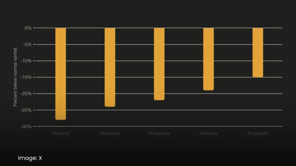
One of the clearest channels through which this mechanism is translating into economic damage is agriculture. Slackening Pacific winds are stripping vital moisture from Malaysia, Singapore, Indonesia, Thailand and the Philippines, with rainfall deficits across the region running as high as 28 percent below normal between April and July. These countries are major exporters of rice, sugar and corn, and prolonged drought conditions threaten crop failures that would ripple well beyond the region, driving up global food prices and straining supply chains already under pressure from extreme weather elsewhere.
The Economic Cost of the 2026 Super El Niño
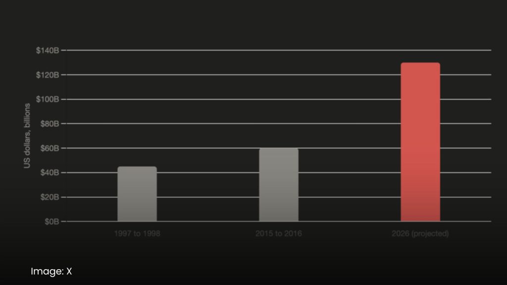
The financial toll is expected to dwarf previous cycles. Global economic losses from El Niño driven disasters are projected to reach roughly 130 billion dollars in 2026, more than double the losses recorded during the 1997 to 1998 event and significantly higher than the 2015 to 2016 cycle. These losses stem from infrastructure damage, healthcare costs tied to heat emergencies, and supply chain disruptions across agriculture, energy and transportation sectors simultaneously.

What This Means Going Forward
Taken together, the human, agricultural and economic data point to the same underlying story. This isn’t an unusually bad year layered on an otherwise stable climate. It’s what a strong El Niño looks like once it forms on top of a climate system that has already shifted, and it offers a preview of how future El Niño cycles are likely to behave as background warming continues to rise.
Sources:
· What previous Super El Niños can tell us about the next one — CNN: https://www.cnn.com (referenced via search results, May 19, 2026)
· Historic El Niño able to supercharge extreme weather looks — The Guardian: https://www.theguardian.com (referenced via search results, July 10, 2026)
· Not a run of the mill El Niño, forecasters predict historic event — PBS: https://www.pbs.org (referenced via search results, July 10, 2026)